Brown County Water Wars: Beer's for Drinking, Water's for Fighting
Steven Dutch University of Wisconsin - Green Bay
Ground Water Terminology
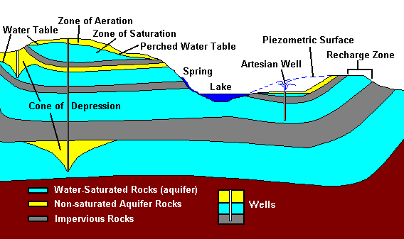
- Aquifer
- Rocks capable of holding ground water in pore spaces or fractures.
- Aquitard
- A relatively impervious layer that blocks groundwater flow. Once called "aquicludes," except no layer is absolutely impervious to leaks. Shown in gray in the diagram.
- Zone of Aeration
- The portion of an aquifer where pores are at least partially filled with air. Shown in yellow on the diagram.
- Zone of Saturation
- The portion of an aquifer where pores are filled with water. Shown in blue on the diagram.
- Recharge Zone
- Area where surface water can enter rocks of an aquifer.
- Water Table
- The boundary between the zone of aeration and the zone of saturation.
- Piezometric Surface
- "Pressure measurement surface." A more accurate and preferred term for "water table." In some cases, ground water is under pressure. The Piezometric Surface is the height to which pressurized water would rise if it were allowed to flow freely.
- Artesian Well
- A well where pressurized ground water rises. Artesian merely means the water is under pressure. It need not be pure.
- Perched Water Table
- A water table that exists because of impervious underlying rocks.
- Cone of Depression
- Area around a well where the water table is lowered by withdrawal of water from wells.
Ground Water in Green Bay
Fortunately, the Green Bay area has some excellent groundwater information available. The diagrams are based on data in Knowles, D.B., 1964, Ground-water conditions in the Green Bay area, Wisconsin, 1950–60: U.S. Geological Survey Water-Supply Paper 1669–J, 37 p. and Knowles, D.B., Dreher, F.C., and Whetstone, G.W., 1964, Water resources of the Green Bay area, Wisconsin: U.S. Geological Survey Water-Supply Paper 1499–G, 66 p. Diagrams here are based on Water Supply Paper 1499-G.
If I were going to write a textbook on ground water, I'd use Green Bay for a case study. It's that good.
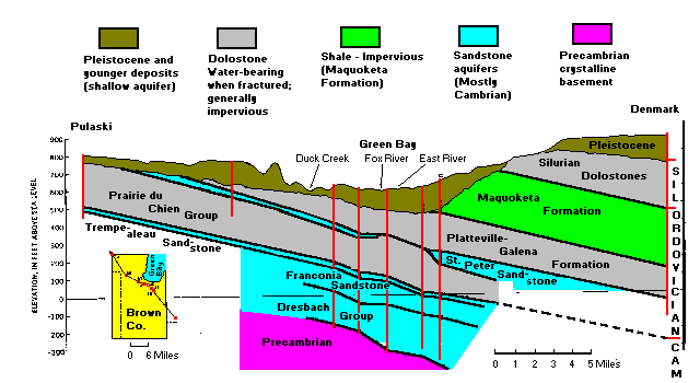
A NW-SE cross-section through Green Bay, roughly perpendicular to the strike of the layers. The vertical scale is highly exaggerated and the actual dip of the layers is less than one degree. Red vertical lines are wells used for subsurface data. Some geologists prefer to distinguish "dolomite," the mineral, from "dolostone," the rock made mostly of dolomite. In practice there is little confusion.
From bottom to top, the rock units are:
- Precambrian
- Mostly granite, not a significant source of water, however, a source of radium that can be a problem in some wells
- Cambrian Sandstone
- The principal deep aquifer in northeastern Wisconsin. Outcrops at the surface in central Wisconsin. Since the recharge zone is higher than the surface at Green Bay, wells in this aquifer were actually artesian when first drilled.
- Prairie du Chien Dolomite
- The dolomite units are impervious when solid but transmit water when fractured. This unit is mostly buried but outcrops as an escarpment just east of Shawano.
- Saint Peter Sandstone
- Thin and discontinuous, so not a major aquifer. Also contains arsenic-bearing minerals that cause problems in places.
- Platteville-Galena Dolomite
- Impervious when solid but transmits water when fractured. Underlies the west shore of Green Bay and outcrops in numerous quarries
- Maquoketa Formation
- Shaly dolomite and a major aquitard. Separates ground water in the Silurian dolomite from the ground water below. Exposed at Wequiock Falls.
- Silurian (Niagara) Dolomite
- Highly fractured. The fractures have been widened by solution. There are some small caves, mostly at Brussels Hill and Maribel Caves, and numerous sinkholes and other karst features. Because of the open fracture systems, this is a significant aquifer, but the same fractures can allow contaminants to enter the ground water and travel long distances. Since the Silurian dolomite is bounded below by the Maquoketa aquitard, it is an example of a perched aquifer.
- Pleistocene Deposits
- A shallow aquifer where the deposits are sandy. Suitable for individual small users but not large scale water supply.
Water Usage in Green Bay
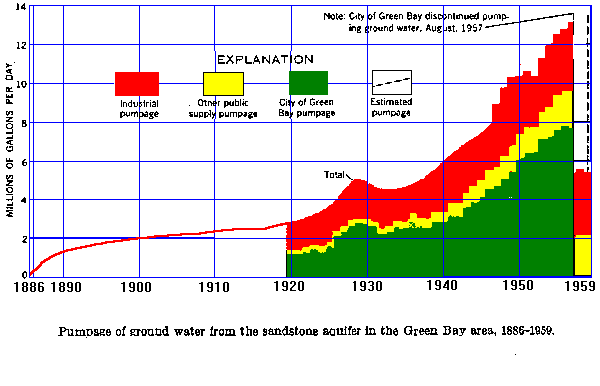
Above: water usage from the deep aquifer 1886-1959. Note that once Green Bay ceased municipal pumping and began piping water from Lake Michigan in late 1957, water use dropped to what it had been about 20 years earlier. However, other users continued to pump about 40% of the pre-1958 total, so significant exploitation of the deep aquifers continued.
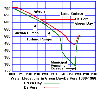
Elevation of the piezometric surface at Green Bay (green, of course) and De Pere 1880-1960. The horizontal lines show the elevation of the land surface. Before 1900, the piezometric surface was substantially above the ground surface. The wells were artesian wells and high pressure artesian wells at that.
Shortly after 1900, the piezometric surface had dropped to the elevation of the ground surface, and pumping was required. Initially, suction pumps were used, Since suction pumps lift water only about 30 feet, predictably enough, they ceased to be effective and were replaced by in-well turbine pumps.
The accelerating drop after 1938 was a clear signal something needed to be done. In 1957, Green Bay started using a pipeline from Lake Michigan, and the piezometric surface recovered rapidly.
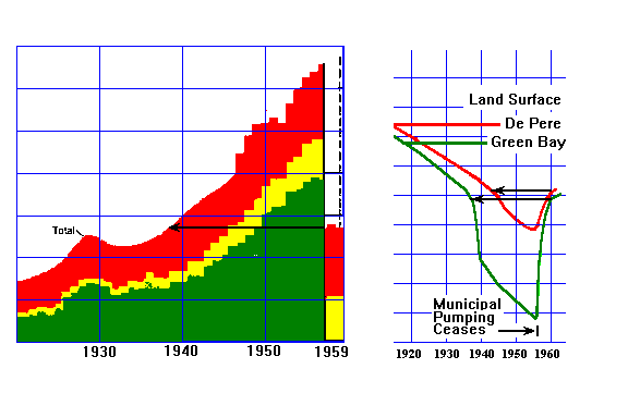
A comparison of the water usage and piezometric surface plots shows that the Piezometric surface recovered astonishingly rapidly once municipal pumping ceased. Pumping decreased to the levels of about 20 years earlier, and the piezometric surface also recovered to the level of about 20 years earlier.
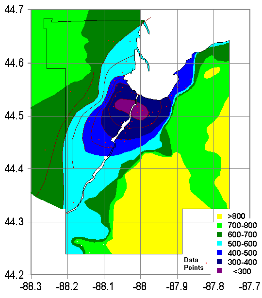
Ground Water Elevations: 1957-2009
Ground Water Elevation: 1957
By 1957, over-pumping of the Cambrian aquifers had created a classic cone of depression beneath Green Bay. There was still a long way to go before depleting the aquifer, but over-drawing could also mobilize dissolved minerals and affect the water quality. And it was clear that things could only get worse. So in 1958, Green Bay began using a pipeline from Lake Michigan. Diagram based on Water Supply Paper 1499-G.
The Silurian aquifer (the areas generally above 700 feet in the east and southeast) is a perched aquifer not connected to the Cambrian sandstone aquifer. The water table here is shallow and generally follows topography.
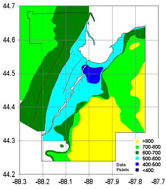
Ground Water Elevation: 1957
By 1960, only two years after changing from wells to a pipeline, the water table had recovered dramatically. There is still a cone of depression, buy it's much shallower and smaller. There were still private, industrial, and municipal wells outside of Green Bay drawing water. Diagram based on Water Supply Paper 1499-G.
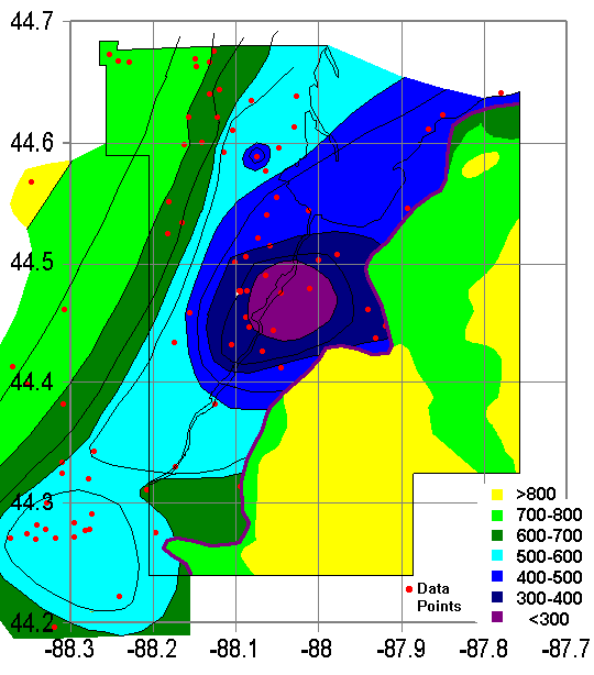
Ground Water Elevation: 2003
By 2003, continued pumping in the growing suburbs created a new cone of depression. Note the far larger number of data points in 2003. The cone of depression is deeper than in 1960, and also further southwest.
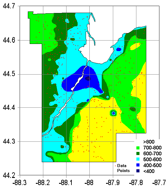
Ground Water Elevation: 2005
By 2005, the cone of depression was larger and deeper than the one in 1957, and centered south of Green Bay, reflecting the increased water usage by the suburbs. Data after Maas, 2009.
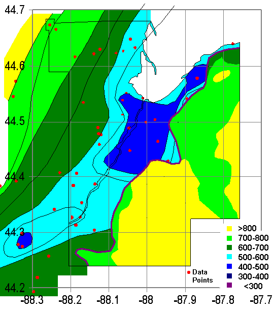
Ground Water Elevation: 2009
The deepening cone of depression led the suburbs of Green Bay to consider using Lake Michigan water as well. Their first thought was simply to use Green Bay's system. Green Bay's response was "Sure! How much are you willing to pay?" To which the suburbs replied "pay?" Eventually, six surrounding communities decided to build their own pipeline, which opened in 2006.
By 2009, the cone of depression, though still large and deep, has substantially ameliorated. Water table recovery has been enough to restore artesian conditions in some areas. Data after Maas, 2009.
References
- Knowles, D.B., 1964, Ground-water conditions in the Green Bay area, Wisconsin, 1950–60: U.S. Geological Survey Water-Supply Paper 1669J, 37 p.
- Knowles, D.B., Dreher, F.C., and Whetstone, G.W., 1964, Water resources of the Green Bay area, Wisconsin: U.S. Geological Survey Water-Supply Paper 1499G, 66 p.
- Maas, Julie C. Drawdown, Recovery, and Hydrostratigraphy in Wisconsin's Northeast Groundwater Management Area (Brown, Outagamie, and Calumet Counties). Master's Thesis, University of Wisconsin, Green Bay, WI, USA, December 2009.
Return to Geology of Wisconsin Index
Return to Professor Dutch's Home Page
Created 22 September 2003, Last Update 19 January 2020